How You Actually Get Drone Data Accuracy Down to a 10th of a Foot
Whether you’re in the earthworks, mining, aggregates, or waste management industry, accurate survey data is critically important. More and more, teams are replacing traditional survey methods with faster, more affordable drone surveys to promote safety and environmental sustainability on the jobsite, track progress, calculate stockpiles, and more. Now, obtaining accurate surveys is as simple as flying your drone over your site, collecting data, and then uploading it to a drone data analytics processing platform. The 3D site surveys you get back will help you manage jobsite productivity, quality, and costs. However, do not forget to organize a drone training program and solutions workshop to train your team on proper drone usage.
Those new to drones may focus on the hardware—the drone itself—when implementing a drone survey program, but the software platform used to process the drone data is an even more important consideration. An all-in-one processing solution featuring a PPK workflow, like Propeller Aero, is making it easier than ever for professionals to turn drone-collected data collected into 3D site surveys that are accurate to 1/10th of one foot. Read on to learn how you can achieve this level of reliability.
The basics of PPK
Drone surveying uses two main types of technologies—post-processing kinematic (PPK) and real-time kinematic (RTK). While both methods can provide accurate drone mapping data, PPK is the easiest way to capture and collect data since it takes less time to establish and set ground control points.
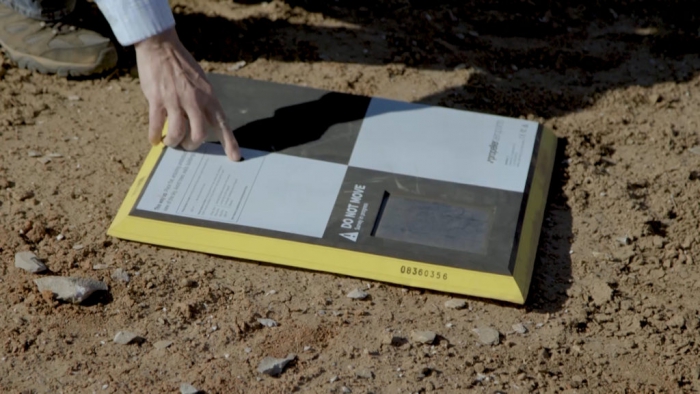
In a PPK workflow, data is processed post-flight rather than in real time. While the drone collects data with RTK technology, operators use data collected from carefully-placed ground control points, like Propeller’s AeroPoints, to correct any inconsistencies in the drone data.

Ground control points are crucial
While RTK processing may sound attractive, you need uninterrupted communication lines to correct location data. You’ll still need ground control points to correct the data collected by drone, since RTK craft alone can’t achieve the accuracy you need to gain meaningful information from your survey data.
The truth is, you always need at least one ground control point to reconcile drone errors. Proper placement of ground control points helps you achieve incredible accuracy—down to 1/10th of a foot. With Propeller’s streamlined workflow, you only need to place one AeroPoint on the ground to verify your data, which is much quicker than using traditional ground control setups. Another consideration for drone surveying is employing a local coordinate system that covers a small region or site and features an ultra-specific grid.
All it takes is three simple steps—placing your AeroPoint, flying your drone, and uploading your data to the Propeller platform—to get reliable, accurate site surveys you can use to track progress and make better project decisions. With this approach it’s now easy to get the reliability you need from your surveys, enabling centimeter-level accuracy you can’t always achieve with RTK.